


Cycling Mt. Hood, Oregon

I like to map out bike touring ideas in my spare time, and had my eye on Mt. Hood, Oregon for a while. Large, dramatic mountains like that one always stood out to me, especially when planning bike trips along the nearby highways. And on the northern end of it, the Columbia River Gorge is recognized by many people as one of the “Most Scenic Rivers in America”. Also a great place to ride. It made sense to plan some kind of tour that would include a climb up the mountain and then a ride down the side of the gorge along the river, starting and ending the trip from Portland.
But the bigger thing that got my attention when I was poring over this idea was Glacier National Park, Montana. I’m a lifelong fan of the Shining. It is a cult horror masterpiece that I never get tired of watching, one reason being the outdoor shots of the mountains surrounding the hotel. I watched it one evening last year and remember thinking that the opening sequence looked strangely familiar. The small island in the middle of the lake, the big mountains to the left, the winding road through the forests and alpine mountainsides, were not of Colorado where the story takes place. They were along Montana’s famous Going To The Sun Road.
I looked up the filming location online. Sure enough, it was the same spot that I was already scoping out for a bike tour. I kept reading and realized that the Overlook Hotel at the end of the opening scene wasn’t in Colorado either, but in Oregon. The Timberline Ski Resort on the south face of Mount Hood. Perhaps I could bring Montana and Oregon together, tour both of them back to back, and by doing so, pay a homage to the opening sequence of the movie.
It took a lot of logistics, planning, trial and error, phone calls, and hassles, but I did it. I left on July 3 on an uneventful flight into Portland and stayed with my friend Alison, who lives in the Northeast Side. We hung out with her friends on the 4th, and I left early the next morning on a train to Gresham, a suburb west of the city.
Day 1
I planned on looping around the mountain, making Gresham my starting and ending point. It would take three days to do, the first being entirely uphill on the Mt. Hood Highway for 32 miles, where I would meet up with Alison and her boyfriend at a campground. On the second day, I would continue climbing to the town of Government Camp, which sits on the south face of the mountain, and then ride six painful uphill miles at a 6% grade to Timberline. Then I would come flying back down and continue around the side of Mt. Hood, and descend for 30 miles to my hotel in Hood River. On the third day, I would follow the river back to Gresham along the Columbia River Gorge and take a train back to the city.
The train reached Gresham in the late morning, and I got moving at a good pace out of suburbia and into the great forests of northwest Oregon. The sun had a halo as it moved along behind a thin band of overcast, but it was shaping up to be a sunny day, and a sunnier weekend. Out ahead, Mt. Hood appeared as the road wound about towards it.
After an hour, I started going uphill. It was easy climbing, but I knew that volcanoes get exponentially more and more shitty as you go up the face of them. I found that out the hard way in Hawaii. But I was determined not to let that happen this time. I had spent the entire month building up to this trip on a spin cycle, training my ass off. The buildings, side roads, homes became increasingly sparse, the grade got worse, and I climbed up the mountain between rolling ridgelines in the midst of a vast evergreen woodland.
I remember the forests of Oregon. They’re big. Everything about them. I knew that because I had hiked a manly 20 miles in Forest Park before in the winter, when clouds were low, casting drizzle and darkness on the trail. The woods were tall and thick, and moss seemed to engulf any trees that weren’t big enough to outgrow them.
There weren’t any clouds out this time, as it was the dry season of the northwest. But instead, the blazing sun stood high in the sky, and got to be quite horrible by the early afternoon.
I made it to the campsite, and spent the evening with Alison and her boyfriend. Whenever I tour, I try to find friends to join me on my camping stops. It makes for a more interesting trip with people around, and I get to enjoy all the luxuries of car camping, like grilled meat and beer. I slept well by the rush of a cold mountain stream.
Day 2
I got moving early the next day. There was quite a bit to do, and I needed as much of the morning as I could get to do it. The highway off of the campsite went straight into a 5% grade that woke me the hell up. I downshifted as low as I could go and pedaled slowly, like I had taught myself to do at the gym. The good news was that the Hood Highway was very well maintained, and had a huge shoulder. So even though cars went flying by, I had plenty of room to ride.
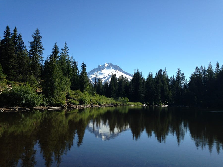
The road climbed over a large hill and finally started leveling out close to Government Camp. To my right was the trailhead to Mirror Lake, one of the most popular hiking locations in the state. From the highway, the trail ascends steeply over a ridge for just over a mile before reaching the edge of the lake. From there, Mt. Hood stands above its reflection, creating a vista that turned out to be one of my favorites on the trip. Hiking up there with my pannier bag was a hassle (I’m a jaded Chicago cyclist and didn’t want to leave it unlocked on the highway), but it was worth it
.I scuffled back down the ridge and rode into Government Camp. All this running around was making me hungry, and I needed protein for the climb up to Timberline. I got breakfast at a cafe and had a quick look around of the town. It was almost entirely focused on outfitters, gear, and tourism related to the Timberline and Mt. Hood Meadows Ski Resorts. The place was bustling, even in the summertime. In spite of a blazing sun at high altitudes, Mt. Hood is big enough to retain a good snowpack in between its ridges, drawing skiers and snowboarders all summer long.
I was loaded on calories, protein, and caffeine. It was time to do this. I turned uphill on the Timberline Highway to suffer my way up a 6% grade all the way to the Overlook Hotel.
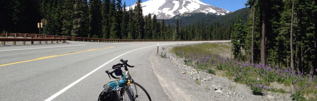
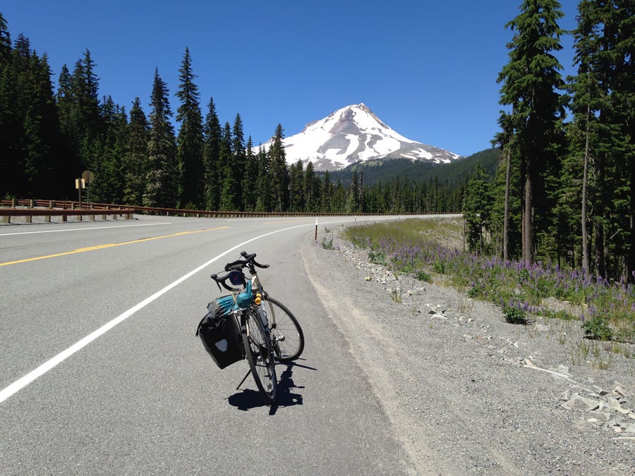
I found a low gear that was comfortable and stuck with it. Before long, I was bending around ledges above the surrounding ridge lines, and I could see out in the clear for 100 miles. Oregon’s rugged countryside faded into waves of green, and surrounded other snowcapped peaks of the Cascade Range. I continued climbing into a thinning forest, unsure of how far much farther I had to go to reach the base lodge. When I finally did, the score to Kubrick’s film clamored in my head as if I were in a large mountainside amphitheater, hearing that masterpiece of a soundtrack echo across an endless expanse of thin air.
The Timberline Highway had one final steep incline before reaching the parking lot. It made my thighs burn like hell, but I was at the top and out of breath before I knew it. I was actually kind of surprised at how difficult that wasn’t. On a scale of 1 to miserable, I gave it a 6, feeling pretty good and satisfied that I made it up there so easily.
First of all, I trained a lot leading up to it, and secondly, I hit the climb the way you’re supposed to. Downshift to a low, comfortable gear, keep a high cadence, and just sit and slowly climb. Eventually you’ll get there. In the past, I had hit those kinds of grades standing on high gears, and got worn out and beat up in no time. Lesson learned.


I had a look around. The lodge stood resolute in its haunting geometry on the side of the mountain just above the tree line. After it, the mountain continued to rise into the dark blue sky, steepening in channels of melting snow and ash. The lodge itself was bustling with people, many of whom were there to shred into the snow on skis or snowboards, or like myself, wanted to see the place where Jack Torrence tried to murder his family and wound up frozen in an impossibly terrible blizzard. It was good to overhear so many people talking about the movie. It echoed about the place, and there was even a display of Jack’s picture in the exhibit area.
Satisfied, I filled up my water supply, went outside, and left for a swift, easy descent back down to Government Camp. I turned east and spent an hour clearing two more steep ridges on the southwest end before descending for two hours straight all the way to Hood River.
It was good riding, but I was exhausted. All the climbing, along with the heat, wiped me out to the point where I didn’t even try to pedal the descent. I just sat on my bike, out of water, and out of energy, and just let gravity take me down the highway. I went on for at least an hour, exhausted, descending thousands of feet down a steep volcanic valley towards the town and my hotel. Wind blew at me head on, making the heat somewhat bearable. The raging, crashing water of the East Fork Hood River followed along the highway for most of the way.
I got out of the woods after an hour of steep drops and started riding through wine country. To my right, a vineyard went by in rows in front of a barren ridge. Up ahead, the road wound its way about and kept dropping. Finally, I found a roudhouse about 5 miles out of the town to rehydrate, restore my protein levels, and chat with the bartender.
With some renewed strength, I reached Hood River, checked into my hotel, and took a solid nap. When I came back out later to get supplies, the setting sun cast an alpenglow on Mount Adams to the north, reminding me that despite the heat of the late afternoon, summer really is the best time of year in the Pacific Northwest.
Day 3
It would have been sweet to stick around, but I needed to move. I checked out and got moving on I-84 at sunrise. I was right on the eastern end of the Columbia River Gorge, which is a huge canyon that goes along the river from north of Mt. Hood to Portland for more than 80 miles. At its most dramatic point, it cuts right through the middle of the Cascade Range, with a vertical relief of more than 4,000 feet in some places. There are highway systems on both sides that offer great panoramic views of the river and surrounding mountains. It’s just an awesome place to drive, and even better to ride on a bike.
I picked the south side highway, even though I knew it was the less scenic of the two roads. I needed to finish the ride to Portland early so I could have the afternoon to pack up and work out shipping logistics, and the southern route along I-84 would get me to the western train line sooner. The sun had just come over the mountains behind me when I got going.


It was a sweet ride. The highway curved around the steep ashen cliffsides and smaller riverside hills, offering plenty of great lookouts. The midmorning sun glimmered on the water upriver, and out ahead the road followed the lazy river downstream around large, sweeping bends at an elevation decline that was too small to even notice.
I love cycling along bodies of water like this. There usually isn’t much elevation change, and the vistas along rivers tend to be pretty dramatic. Even in the midwest. I hadn’t done a ride like this since I toured Alaska’s Turnagain Arm. Eventually the breathtaking panoramas gave way to less eventful country around Troutdale and Gresham as I caught a train back to the city.
I had some free time the next day to chill out in downtown Portland before catching my train. I found a food cart called Tabor that made a chicken schnitzel that was a huge mess to eat, and tasted amazing. And it is part of my tradition to patronize the Deschutes Brewery anytime I visit town. I’ve been a regular fan of their draughts ever since they opened distribution in Chicago last January. I got their standard sampler and then boarded the eastbound Empire Builder for East Glacier, Montana.


The train left the city and traveled along the northern end of the Columbia River Gorge, opposite from where I rode yesterday. When we reached White Salmon and Hood River, hundreds of kite surfers were out on the river, flipping about in the random wind currents on the water. It is an area that is apparently world famous for it, thanks to the tunnel winds that go through the gorge. On the far shore, a forested ridge rose above the river, and the north face of Mt. Hood stood high above the forests and colorful flurry of kitesurfing on the water. I saw a lot of badass shit on this trip, but that scene easily made its way to my top three favorites.
It would have been the making of a damn fine postcard.
I was done with Oregon for now. I made it to the infamous Overlook Hotel, but I still needed to see the road that Jack and his family drove on to get there: The Going To The Sun Road. The train made its way into central Washington and nightfall.