Glacier National Park
…continued from Part 1: Cycling Mt. Hood, Oregon
Day 1: East Glacier
I woke up somewhere in the mountains west of Whitefish. Looking out, the rolling hills passed by, and an occasional lake appeared. It was 7am, and I needed coffee. We were four hours late, thanks to a delayed connection in Spokane. But I didn’t care. Coffee was all that mattered.
I had left Portland the night before in the late afternoon, passing by the Cascades and into the deserts of central Washington. I had taken my bike up to some high places and saw some great parts of the northwestern country. But it was behind me now, and bigger challenges lay ahead.
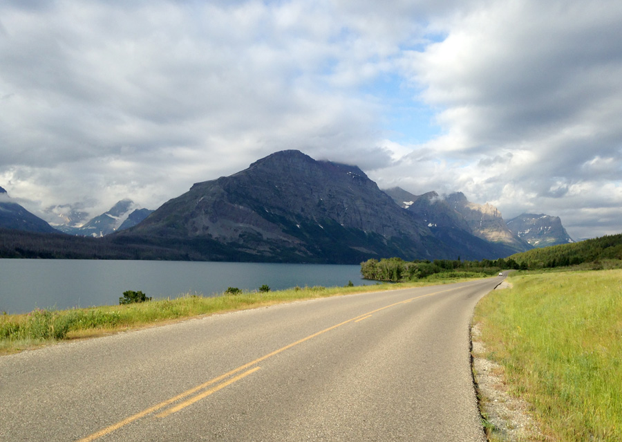
I approached Glacier National Park, the location of my second bike tour on the trip. I planned to tour the Going To The Sun Road, a world famous road that winds treacherously along high mountainsides and through the middle of the park. It draws multitudes of tourists, backpackers, and cyclists every summer. Its panoramas are out of this world, and I finally had my chance to see them.
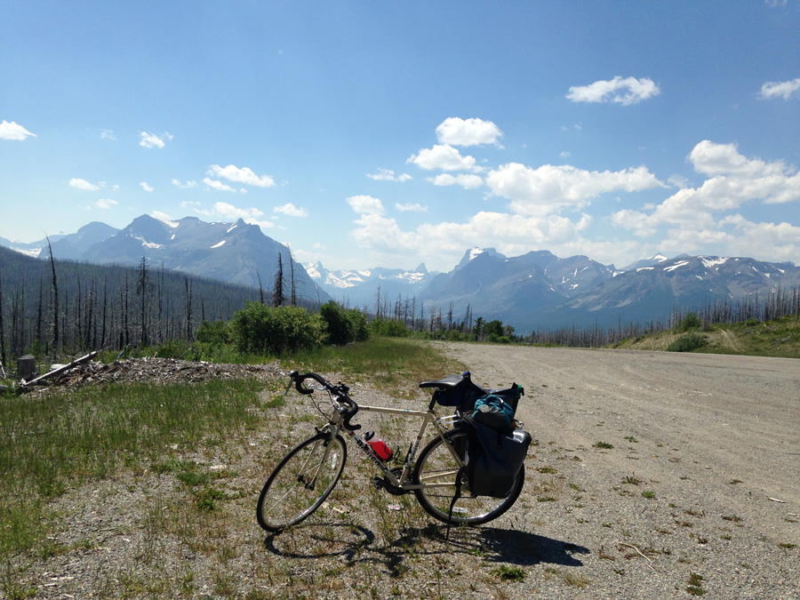
I planned to ride it from the east, starting in East Glacier, 30 miles south of the St. Mary end of the road. I would spend the afternoon of my first day there getting my bike and gear back together, and then leave the next day on a half day ride northward to the St. Mary Campground and the edge of the Sun Road. Then I would spend another day going through the mountains to the western side of the park and pedal out to Big Creek Campground, spend the next day packrafting down the Flathead River, and then end the trip with a short ride to Whitefish.
The train dropped me off in the late morning with my bike box and loaded backpack, which I had to haul across the road to the East Glacier Lodge. My friend Tim recently moved there from Chicago, and worked in the lodge restaurant. He let me crash in his dorm in an extra bunk before my ride the next day. This gave me the afternoon to unpack my bike and get my gear together.
I spent two hours outside of the lodge assembling my bike and organizing gear when I gave it a test run and shifted to slipping gears. I tried turning the barrel adjuster, which has done the job before. Didn’t work, as the derailleur indexing was altogether out.
I should know how to do this. There is a way to change the position by turning the screws. But I don’t remember which way, and this was not the time to really mess something up. I needed it fixed and ready by the next morning.
I made a quick phone call to a bike shop in Whitefish, rented an SUV, threw the bike and my extra baggage in the back, and drove for two hours in the mountains to get it fixed. This wasn’t entirely a waste, as I still had to get my bike box and extra stuff to the hostel there anyway, and this would eliminate the hassle of shipping. So there’s that.
I got to the shop late in the afternoon, and they were glad to take a look at the bike, even though they were way behind on other orders. I dropped it off and went to the hostel to leave my bike box and extra gear. They let me put my stuff in one of the back rooms for the next few days, which was supremely helpful. I sorted out everything that I wouldn’t need to tour, put it in the box, and left it in the back of the building.
How convenient that I was as stressed as I was and right down the street from the Great Northern Brewery, because their Huckleberry Wheat Lager was as delicious as last time. I got a glass of that and a BLT from the kitchen. I was almost done eating when the bike shop called to let me know that my bike was ready.
A well-earned shout out goes to Glacier Cyclery and Whitefish Hostel for helping me work out the details when in a bind. I won’t hesitate to deal with them again, and recommend them to anyone going through that area. I picked up my bike and headed back on a two hour drive to East Glacier, where I dropped the car off and rode my bike back to the lodge.
I found Tim, who was getting a team together to play Ultimate Frisbee in the front lawn. It was the first time I had played a sport like that in years, and I was surprised at how tired I got, despite everything I had done on a bike so far. Our team got whipped for two games, but it was a good time. We finally quit when the sun set behind the western mountains.
Four of us went to the lodge balcony and watched the sky turn red above the huge rugged mountains of Glacier’s eastern edge. It was good to finally relax after my shitstorm of a day. I polished the night off with a glass of bourbon and went to sleep in Tim’s dorm room.
Day 2: St. Mary
I left early the next day for a 30 mile ride northward through the foothills to St. Mary Campground, right by the entrance to the park. There were a few long, steady climbs under the hot sun, but nothing too bad.
The flies were the bigger pain. They flew around me whenever I couldn’t ride fast enough to outrun them. Whenever I got to a climb, they started to land on my arms, legs, face, in the vent holes of my helmet, one even got under my sunglasses. In the middle of one climb, I batted at one, lost my balance, and crashed on the gravel off of the shoulder. I was going too slow to cause any injury, but I scrambled back onto my bike feeling pissed all the same.
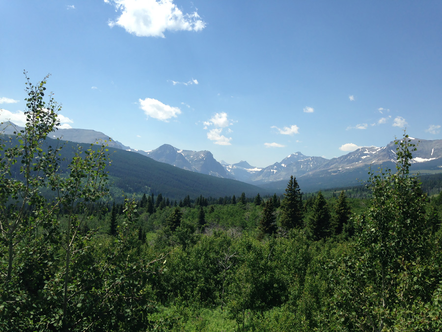
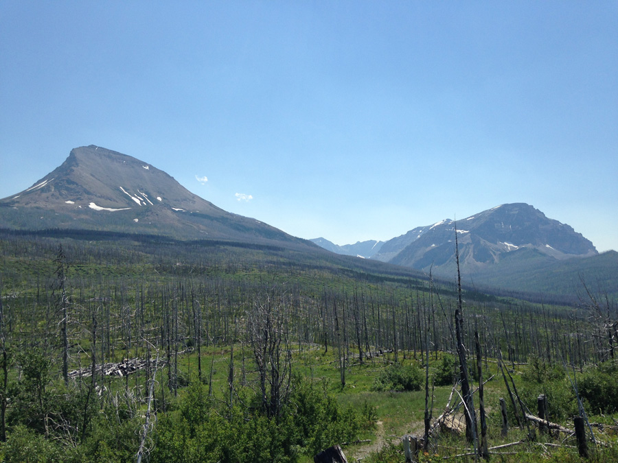
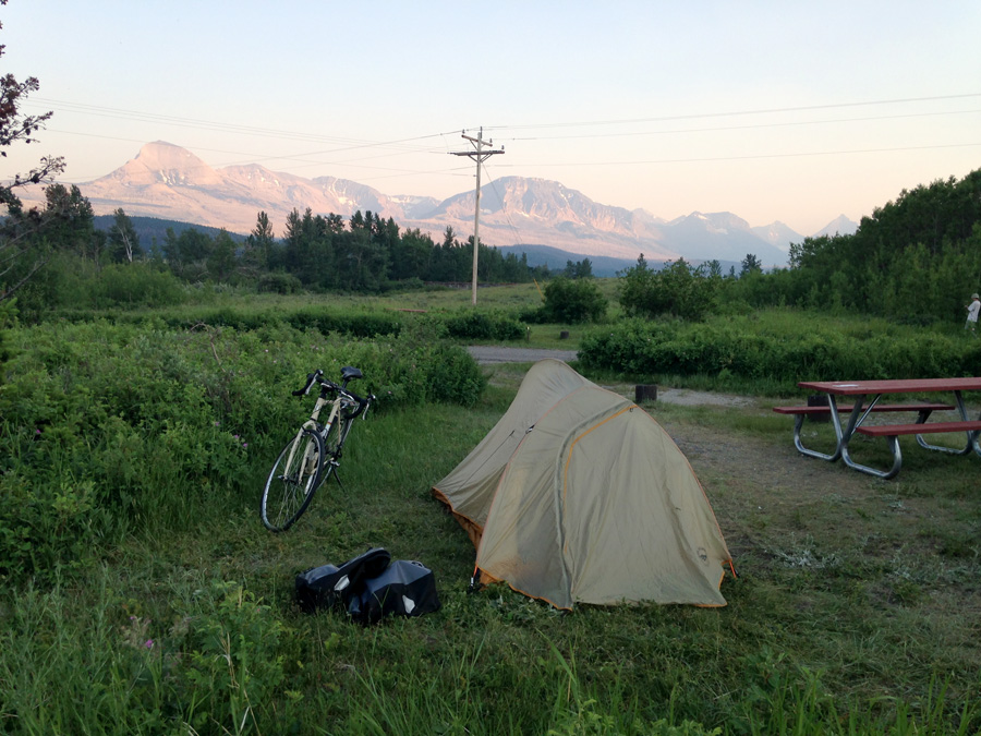
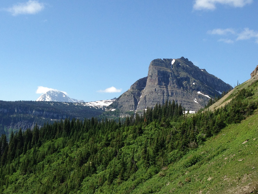
I reached the hills above St. Mary after a few hours. For miles around, countless rolling hills bore the scars of a huge forest fire, likely caused by thunderstorms. Though the woodlands were gone, the countryside nonetheless was vast and beautiful. There is no question that Montana brings with it a tremendous sense of openness and solitude. I descended down a steep hill to St. Mary Campground, checked in, and set up camp along the edge of the range under a blazing mid-afternoon sun.
I went to sleep just after dusk that night. An hour later, the wind picked up, and my eyes snapped open at the sense of lightning flashes outside. Thunder was coming.
I got out and saw a huge thunderhead passing ten miles north. The light of dusk illuminated it from the west, and the rest of it glowed in sight of the rising full moon, flashing and flickering soundlessly into the night. Gusts of warm summer air blew across the campsite, though the storm that caused them was too far away to cause any trouble. To the south, the full moon broke through a band of clouds just above the silhouette of Curly Bear Mountain. Small moonlit clouds raced across the sky above as the night darkened, with stars appearing more and more by the minute.
I see a lot of memorable things on my trips, but there are times when even the best of them don’t come anywhere close to this. On that night, the sight of a giant thunderstorm rolling across an alpine wilderness was a truly otherworldly thing to behold. Unfortunately, I didn’t watch it for long. I needed to get my rest for the next day. I got back in my tent and fell asleep to the rustling wind, which blew against the tent all night.
Day 3: Logan Pass
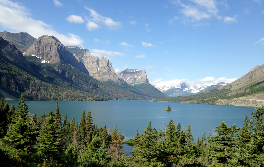
It was game time. I packed up and got moving on the Sun Road at 9:00. It quickly met St. Mary Lake, where it went on for 9 miles. It was mostly flat riding near the lakeshore, with a few negligible hills that I cleared whenever turning towards the mountains to my right.
I recognized all of the places where Jack Torrence drove his family on their way to the Overlook Hotel. I see why Stanley Kubrick picked this road for these shots, and respect is due.
Halfway along the lake, I hit gravel. A girl at the East Glacier Lodge told me that crews were working on the road for 8 miles or so up the east side of Logan Pass, and to expect gravel for the whole thing. Shit. That I did not want to hear.
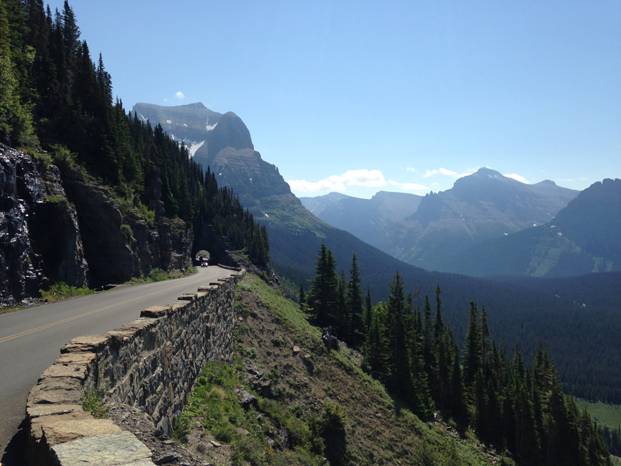
It was already a hard climb just to get up to Logan Pass. At a 6% inclide, 2,000ft elevation gain, the uphill fight lasts for 6.5 miles. Trained or not, it wouldn’t be easy. But with a gravel stretch for the first four miles of the steeper section, it would be even worse. I looked ahead for the smoothest parts of the gravel road and steered accordingly, usually along the tire tread of the vehicles.
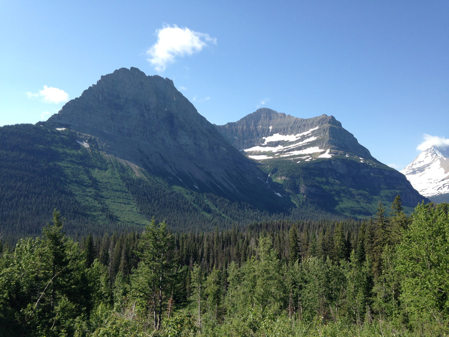
As I approached the pass, the mountains on the far end of the lake seemed even bigger and higher, covering half of the morning sky. The road steepened and turned gradually to the right around Going to the Sun Mountain. This was it. This was the climb. All of the buildup, the hassles, the training, all of that shit. This was what all of my busting ass had come to. It came down to this. Getting through this climb with my sanity, and making it down the other side with my bike in one piece and a story to tell.
I shifted down and slowly pedaled over the dirt and pebbles, looking out at the vistas to the left whenever it was okay to look away from the road. Before very long, the forests disappeared below, and the peaks of Little Chief and Citadel Mountains stood resolute on the far end of a terrifying ravine. I pushed onward, shaded by the trees to my right.
The dirt road finished its turn around the mountain and made straight for Siyeh Bend, a switchback over a small stream between Going To The Sun and Piegan Mountains that marked the second third of the climb, the end of the gravel, and a good place to take a break. When I finally hit pavement again, it felt like a luxury.
I stopped at the overlook, and like the climb up Mt. Hood, was a bit surprised at how much easier it was than expected. Even with cargo, even with gravel, even with a hot alpine sun, it wasn’t that bad. I took a break, feeling pretty good about the two miles I had left. With the help of pavement, I would kick its ass for sure.

I got going and shifted a couple gears up for a smooth pace all the way to the summit. What the hell? It wasn’t supposed to be this easy. It was mildly irritating.
But I made it, and had time to relax.
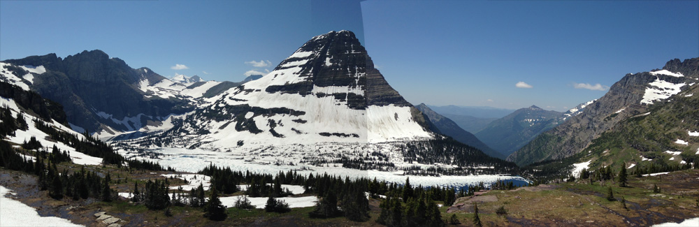
At the top of Logan Pass is a big visitor’s center that is swarming with people in the summer. Inside, they have a few exhibits about the park’s key landmarks and history (disappointingly, nothing about The Shining. You could learn a lesson from Timberline, Glacier National Park), and presentations by the park rangers. I wasn’t really interested in any of this, but I did want to see Hidden Lake, which requires a short 1.4 mile climb over the pass above the visitor’s center. The rangers let me leave my panniers safely in their break room, which was cool of them, and I started climbing up the trail.
What I didn’t realize was that even though it was the middle of the summer, and the alpine sun was blazing on the mountainside, the snowpack was STILL THERE, and was taking forever to melt. Almost the entire trail, a wooden walkway that can be easily traversed when you can actually SEE IT, was covered in snow. I did something that I don’t recommend, and hiked it wearing Keens and wool socks.
Every minute or so, snow would pack into ice under my feet, freezing whatever it could through the layer of wool. It was never cold enough to cause any worry, given that the wool insulated just well enough, and there was the sun helping to thaw my feet out from a horrible angle in the sky. I scrambled along, with sandals slipping every few steps up the snow, and the glare of the ground turning pink in my vision, thanks to my losing my sunglasses yesterday in St. Mary.
It went on like that for a shitty hour. I finally made it to the wooden platform and lookout to the lake. Disappointing. The small valley and lake were still melting in snow as well, and it just looked like a slushy mess. I figured it would look a lot more picturesque later in the summer, but for now, was way off on the cost/benefit ratio. But hey, how could I have known if I hadn’t gone out there, right?
(Actually, I stand corrected in hindsight. I just went back and edited this panorama, and realized the extent of my mistake.)
I walked, trotted, and slid down the snowpack for another hour before finally getting back to the visitor’s center. It was time to get my stuff and get going. The western end of Logan Pass descends at the same 6% grade as it does coming from the east, the key difference being the distance of the descent. It goes farther down, dropping another 1,000 feet in elevation before reaching Lake McDonald and the western side of the park. So whether you climb from that way, or you descend it, you’re going for longer. That aside, it’s pretty much the same.
Passes like this pose two big challenges to me: First, getting up to the top of them, and second, flying back down without crashing and busting my crazy ass on the side of a cliff. I made it up there easily enough, but knew that getting down the other side would mean a steep descent along the twists and bends on the vertical face of Pollock Mountain.
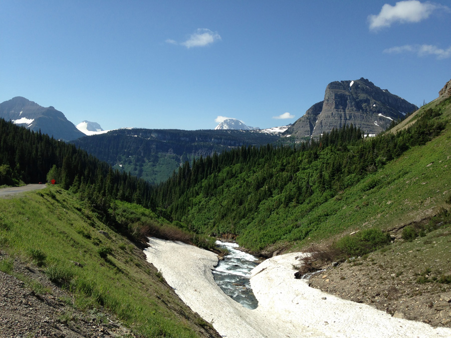
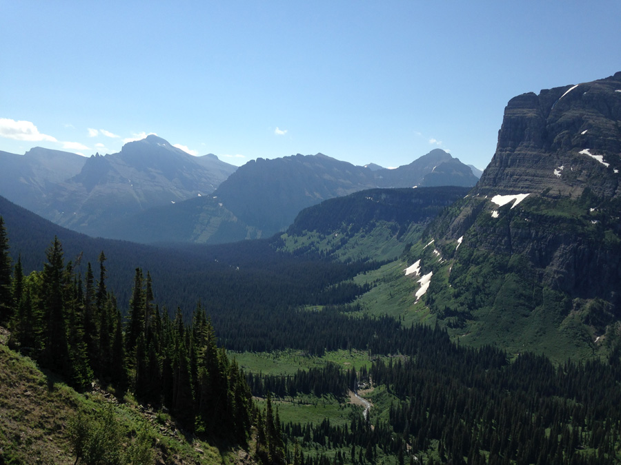
I got started downhill behind a car and a utility truck in front of it. We quickly descended out of the pass and started winding along the mountainside, going past waterfalls and streams of fresh snowmelt. Mt. Oberlin stood high across the canyon to my left in resounding magnificence. Before long, the view down McDonald Valley opened to the west in a forested carpet, fading into the haze of the afternoon.
I continued flying down the turns and bends of the Sun Road, amazed that I could keep up with the cars in front of me. I realized that vehicles on this road were pretty slow going. And at that descent, I was obviously going faster than usual. I went by the Weeping Wall, a spot where small waterfalls pour onto the side of the road, and got a fresh spray of mist in my face. I didn’t care. I was having too much fun.
I chased a car around The Loop, the lone switchback on the western side, and descended two more miles through forests to McDonald Creek and the end of the grade. From there, it was smooth riding all the way to Lake McDonald.
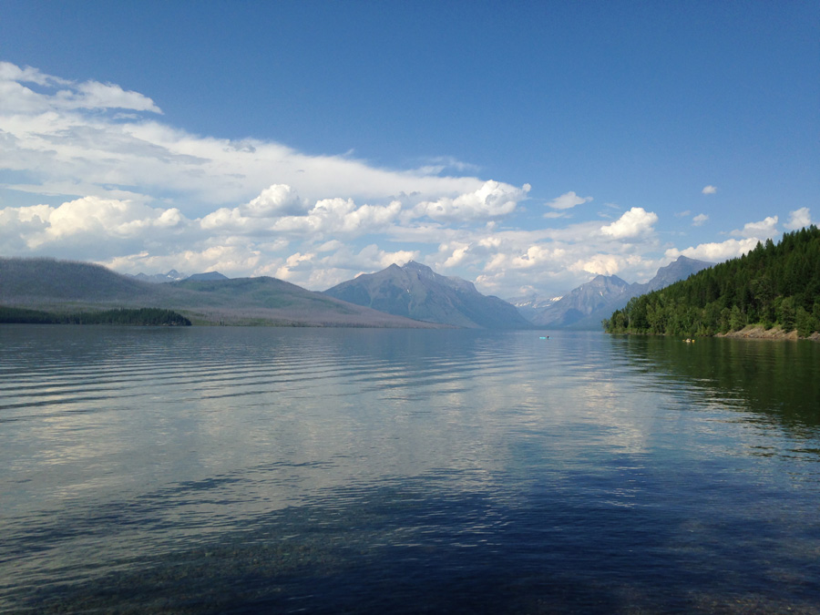
I was surprised at how smooth, driveable, and bikeable the road was, gravel aside. I guess if the state spends millions each year to keep it open, it better be. It is certainly one of the best roads I have ever seen on a bike, and I was satisfied that I finally got the chance to ride it after more than a year of buildup.
But the day wasn’t over yet. I still had to ride another 30 miles to Big Creek Campground, and I was in no mood to do it. I went along Lake McDonald at a worn out pace for 10 miles, turned north at Apgar Village to Camas Road, climbed for 45 minutes uphill, then descended the same distance down to the Flathead River. From there I turned west, and pedaled a final shitty three miles in gravel to Big Creek, checking in a couple hours before sunset. That night, I slept well by the rush of the Flathead North Fork. I was wiped out, and needed all the rest I could get for what would certainly be a big river trip the next day.