


Harpers Ferry by Packraft


A lot of things come together in Harpers Ferry. It is the confluence site of the Shenandoah and Potomac Rivers, the AT and C&O Towpath crossing, three state borders, and one major Amtrak line. And it is the site of a historic Civil War battlefield now owned by the National Park Service. Yet for all its beauty and rich history, the town remains small and quaint, resting on the hillside above the river confluence and old railroad bridges.
After a family visit, my dad dropped me off at the Harpers Ferry Hostel just outside of town. I planned to float the Shenandoah the next day before heading back to Chicago on the train. First though, I wanted to make a scuffle up to the Maryland Heights Overlook for a great view of the town. This marked the end of my summer, and it was a good one. There were adventures to be had, friendships to be made, and obsessions to fulfill. And at the end of it, there was a red sun in the west.
I finally got the wide angle shot of the town that I liked and started packing up when I heard somebody say “Want me to take your picture with the sunset?” It was Megan, a woman from Baltimore on a weekend trip in the mountains. We traded cameras and got our shots, luckily in a 5 minute window before the sun went behind the trees ahead.


We hiked back down the ridge. She told me about a huge road trip she took to the national parks out west, and I told her all about Alaska. At the end of the trail we agreed to stay in touch and I made my way back to the hostel in the dark. If it weren’t for that awesome sunset, we wouldn’t have met. But the trail always has a way of bringing people into my life when I least expect it to.
I slept a few hours and left before daybreak for the river. It would be an 8 mile hike to the town of Milville and the public launch to the Shenandoah River. I walked in the dark for an hour before I saw the glow of dawn over the silhouetted mountains. Even then, that early on Sunday morning, plenty of people were driving out on 340.
I got to Milville Road at sunrise, just outside of the town. South on Milville Road is the entrance to the Civil War Battlefield. At the top of this field is Schoolhouse Ridge, one of three ridges used by Stonewall Jackson to surround the Union garrison and the town, ultimately leading to their surrender after three days of fighting. This historic site is now owned and operated by the NPS, allowing people to visit and see the features of this battlefield.


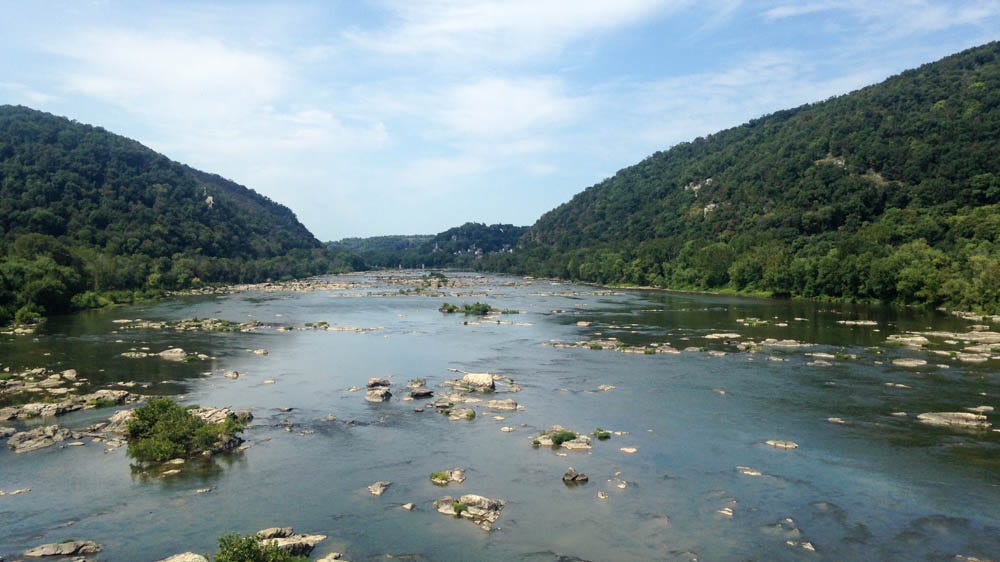
Finally, I got to the boat ramp and paddled into calm water at mid-morning. After going for two miles, I hit the first rapid, an unnamed smooth channel going through a small ledge system. After a short break, I got to Bull Falls, the iconic drop on the river. Here, the river channels into a big V-wave, making for an easy line as long as you can bust through the hydraulic at the bottom. I scouted it from the rocks to the right. Further right was another big slot with a nasty log jam. Stay out if you want to live.
I waited for a guided raft to go over the falls and followed behind them. In a packraft, the best way to hit a hole is to lean forward and paddle hard. If you do it right, you’ll slam through the glassy water at the bottom and come out clean. Up ahead, the current continued into Bull’s Tail, a fast wave train just after the falls. From there, it calmed down for half a minute and channeled into Lunch Rock Follies, another swift channel that carried me into the middle.
After a big flatwater break, I got into eyeshot of the 340 bridge and the top of Staircase Rapids. As the name would suggest, it is a huge series of small ledges that go down the river for a mile.


It was the end of the summer and the local gauge measured at 1.6ft, making for a bony river run. This made for a lot of scraping as I tried to find runnable channels over each ledge. After a half an hour and a lot of swearing, I finally got to the bottom of the Lower Staircase. The last couple ledges here were good, since the river narrows and brings the channels up enough for halfway decent tongue action. Still, I should have followed a guided raft for it. I hear that Staircase is a sick run in the springtime levels, and I don’t doubt it.
I floated past the town and the stone columns of a torn out railroad bridge to the confluence, where up ahead the Potomac joined the river below the rocky cliffs of Maryland Heights. I passed a group of people on innertubes on my way to Whitehorse Rapid, a solid wave train on river left. Finally, I ferried across to the takeout on the right, ending my last big river trip of the summer.


Thanks to Amtrak’s Capitol Limited line, this town is easily accessible, especially now that it has a bike car. I made a note of it as I boarded to leave. And to make a long story short, I did end up coming back on a bike. But that’s another story.
All packed up and Chicago bound!